Wednesday

Hurricane Fred gets stronger far out over Atlantic


MIAMI — Hurricane Fred has quickly strengthened to a Category 2 storm but remains far out in the eastern Atlantic with no signs it will threaten land.


The National Hurricane Center in Miami says Fred could become a major hurricane later on Wednesday. The storm's projected five-day path will keep it over the open ocean until it loses steam.
Fred's maximum sustained winds have increased to near 105 mph. Forecasters say it could become a major hurricane, meaning top sustained winds of more than 110 mph.
The storm is centered about 500 miles west-southwest of the southernmost Cape Verde Islands and moving west-northwest near 13 mph.


Meanwhile, Tropical Storm Linda is drifting slowly far out over the Pacific with maximum sustained winds near 65 mph.


Tuesday

Mexico tries to evacuate thousands ahead of Jimena

By MARK STEVENSON, Associated Press Writer Mark Stevenson, Associated Press Writer –

LOS CABOS, Mexico – Emergency workers struggled to evacuate thousands of reluctant slum dwellers as extremely dangerous Hurricane Jimena approached Mexico's resort-studded Baja California Peninsula on Tuesday.

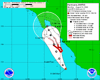
Jimena, just short of Category 5 status with winds of near 155 mph (250 kph), could rake the region of harsh desert fringed with picturesque beaches and fishing villages as a major hurricane by Tuesday evening.

Police, firefighters and navy personnel drove through shantytowns, trying to persuade some 10,000 people to evacuate shacks made of plastic sheeting, wood, reeds and even blankets.

"For the safety of you and your family, board a vehicle or head to the nearest shelter," firefighter Ricardo Villalobos bellowed over a loudspeaker as his fire truck wound its way through the sand streets of Colonia Obrera, a slum built along a stream bed that regularly springs to life when a hurricane hits.

Asked how many people were paying attention, he noted wryly, "Not many."

Many residents feared that their few possessions — a TV, radio or refrigerator — would be stolen if they left.

Jose Miguel Leyva, a cab driver, nailed another plastic sheet to his rickety wood framed shack, vowing to stick it out as long as he could.

"We're putting all we can into the house," Leyva said. "They told us to go to a shelter. If it gets bad maybe we will. We can go in my car."

Roberto Hernandez, a community organizer, said he and other activists had formed a security brigade to ride out the storm and watch over their neighbors' possessions. "A lot of times, people steal their furniture, or whatever they can find," Hernandez said.

But Miguel Angel Juarez, an unemployed iron worker, packed clothing and his countertop gas grill into the trunk of his car before taking his family to a shelter.

"I'm not staying here," he said, eyeing the stream bed that runs a few feet from his front door. "They say that when it rains here, this becomes a river."

The government warned that those who refuse to evacuate would be forced to do so.
"We are going to start by inviting people to leave ... the moment will come when we will have to make it obligatory," said Garibaldo Romero, interior secretary for the municipal government.
After official hurricane warnings were broadcast, organizers of an international financial meeting scheduled for Cabo San Lucas this week decided to move their conference — including more than 170 representatives from 54 countries — to Mexico City.

"The meeting has been planned for two months and the meteorological conditions, by their very nature, are unpredictable," said Anthony Gooch, spokesman for the Global Forum on Transparency and Exchange of Information, sponsored by the Paris-based Organization for Economic Cooperation and Development.

Many tourists rushed to leave, leaving hotels with a 25 percent occupancy rate, according to the local hotel association. The group estimated 7,000 tourists were left in Los Cabos.

But on Cabos' famous beaches, some tourists were doing just the opposite, jumping into the Pacific to play in the hurricane's big waves.

Although city officials shut down the port, lifeguard Roman Dominguez with the Cabo San Lucas Fire Department said there's no feasible way to close a beach.

"We struggle a lot with surfers," he said. "They're looking for waves."

Lifeguards perched in a tower looked on Monday as two women, one with her boogie board, another on a surf board, paddled into pounding surf under cloudy skies.

Clay Hurst, 52, a fencing contractor from Malibu, California, and Ben Saltzman, 28, an emergency medical technician from Pacific Palisades, California, emerged from a swim in the 10-to-12-foot (3-to-4-meter) waves and pounding surf.

"We are waiting anxiously, wanting to be right in the middle of it," said Hurst, who said he has never seen a hurricane as powerful as Jimena.

"We were advised to leave, but we want to be here," he said. "I've always wanted to be in one ... a real bad one."

Saltzman echoed his friend's enthusiasm: "It's an adrenaline rush," he said.

Early Tuesday, Jimena was a Category 4 storm with maximum sustained winds near 155 mph (250 kph) and was moving north-northwest near 12 mph (19 kph), the U.S. National Hurricane Center in Miami reported. It was centered about 155 miles (250 kilometers) south of Cabo San Lucas.

Hurricane force winds extending as far as 45 miles (75 kilometers) and tropical storm force winds 140 miles (220 kilometers).

Hurricanes reach Category 5 at 156 mph (250 kph).
Farther out in the Pacific, Tropical Depression Kevin had top winds of 35 mph (55 kph) and was expected to weaken to a remnant low later in the day or Monday night. It was centered 830 miles (1,335 kilometers) west-southwest of the Baja peninsula's southern tip.

Monday

Hurricane Jimena intensifies, prompting warnings in Baja California Sur

As Southern Californians continue to deal with fire and smoke, residents and tourists in Baja California Sur are bracing for the arrival of Hurricane Jimena, an intense storm that might cause widespread flooding and damage.


The 8 a.m. Monday advisory from the National Hurricane Center positioned the eye of the storm 355 miles south-southeast of Cabo San Lucas. It's traveling to the northwest with maximum sustained winds of about 145 mph, making it a Category 4 hurricane. It will make landfall in the Magdalena Bay area late Tuesday or very early Wednesday.


The government of Mexico has issued a Hurricane Warning for the southern half of the state. That means hurricane conditions are likely within the next 24 hours.


Beachfront hotels are shoring up and fishing fleet crews from Cabo San Lucas to La Paz have been pulling boats from the water or moving them to safer areas.


Tracy Ehrenberg, general manager of Pisces Sportfishing in Cabo San Lucas, said Monday morning that seas were calm and the port was still open. In fact, Pisces has two charters today. Ehrenberg expects the typical chaos in advance of a hurricane -- long lines at gas stations, etc. -- to ensue throughout the day.


Mark Rayor, who runs Vista Sea Sport in Buena Vista in the East Cape, took delivery of a Cabo 35 fishing boat Friday in La Paz. A day after he drove the boat south to the East Cape, he drove it back to the protected harbor in La Paz. "The people I bought it from told me it was a lucky boat," he said. "I'm hoping they were right."If there's a silver lining, the region is drought-stricken and parched, and Jimena is already delivering showers. Said Eric Brictson, owner of Gordo Banks Pangas: "It has been a while since we have been hit, so this could be the one one that finally brings some much-needed rainfall."


Outposts will provide updates or new items on Jimena as warranted.--Pete Thomas

Thursday

Hurricane Danny (1997)

From Wikipedia, the free encyclopedia

This article is about the Atlantic hurricane in 1997. For other storms of the same name, see Hurricane Danny was the only hurricane to make landfall in the United States during the 1997 Atlantic hurricane season, and the second hurricane and fourth tropical storm of the season. The system became the earliest 5th tropical or subtropical storm of the Atlantic season when it reached tropical storm strength on July 17, and held that record until the 2005 Atlantic hurricane season when Tropical Storm Emily broke that record by several days. Like the previous four tropical or subtropical cyclones of the season, Danny had a non-tropical origin, after a trough spawned convection that entered the warm waters of the Gulf of Mexico. Danny had an extended northeast track through the Gulf of Mexico, caused by two high pressure systems, a rare occurrence in the middle of July. The storm moved across the southeastern United States, after making landfall in the Gulf Coast, and affected parts of Massachusetts with rain and wind.


Danny is noted for the extreme rainfall, tornadoes, and damage it produced on its path, causing four direct fatalities and $100 million (1997 USD, $128 million 2007 USD) in damage. The storm dropped a record amount of rainfall for Alabama, at least 36.71 inches (932 mm) on Dauphin Island. Flooding, power outages, and erosion occurred in many areas of the Gulf Coast, and rescues from flooded roads had to be performed. Various tornadoes on the East Coast caused a great amount of damage. Danny caused one death off the coast of Alabama, four deaths in Georgia, two deaths in South Carolina, and two deaths in North Carolina.

Wednesday

LOOK OUT! HERE IT COMES!


Tropical Storm DannyHurricane DannyHurricane Danny 2009


Tropical disturbance in the western Atlantic is developing a well-defined center of circulation and very likely will be designated Tropical Storm Danny later today, the National Hurricane Center said.

The storm has top winds of 45 mph and is moving to the west-northwest at 18 mph. As of 11 a.m. EDT Wednesday, the storm’s center was about 445 miles (715 kilometers) east of Nassau, Bahamas and about 775 miles (1,250 kilometers) south of Cape Hatteras, N.C.

The current forecast has the storm on a path to clip the U.S. East Coast over the weekend, but a storm’s track can be difficult to predict days in advance. People in the Bahamas and the southeastern U.S. are advised to monitor the storm.

Meanwhile, far out in the Pacific, Tropical Storm Ignacio has weakened as it moves northwest with top winds of 45 mph.

Danny previously was used to name a July 1997 hurricane that brought record rain fall for Alabama, at least 36.71 inches on Dauphin Island. That storm was the only hurricane to make landfall in the United States during the 1997 Atlantic hurricane season.

Tropical wave brewing....expected to become Hurricane Danny


TAMPA – Forecasters seem confident the season’s fourth named Atlantic storm could appear today.


A tropical wave about 470 miles east of the Bahamas has the potential to become a tropical depression or storm at anytime as it enters a section of ocean where high level winds and water temperatures will make things cozy for a developing storm.


A hurricane hunter aircraft has been dispatched to explore the disturbance that is developing a well-defined circulation, a sign it’s working up to a tropical cyclone.


Forecasters believe the tropical wave will skip the depression level and go straight to a tropical storm.


Intensity models run early today already have the disturbance at tropical storm strength.
Most of those models also have the storm reaching hurricane strength around Sunday, though all project it staying below Category 2 strength.


It is heading to the west-northwest at about 15 mph, the National Hurricane Center says.
None of the track models have the system threatening Florida, but folks farther north on the East Coast may need to pay attention.


The track models are fairly well clustered and generally predict the storm will pass north of the Bahamas and curve toward Bermuda, similar to the path taken by Hurricane Bill, although the model tracks take the storm closer to the United States coast than Bill.


Some of the models have the storm going near the Carolinas or Virginia, but most show it heading toward the Canadian Maritimes by the end of the weekend.


If it becomes a storm, it would be named Danny.